top of page

The Presidents Trail
Quincy, MA
.png)
A cohesive system that provides an ultimate navigational experience.

OUR GOALS
1
How to make people want to move forward along the trail?
It is important to consider people’s interest to walk the trail, to stay on course and continue walking the trail.
2
How to enhance and create attractors to facilitate trail exploration?
Trail exploration is very crucial, therefore, identifying interesting points along the trail is also important.
3
How can the trail be like a book that a visitor reads while walking along the trail?
Being aware of your whereabouts and being informed about places you visit enhances the experience.
Field Research / Observation
We met with the Mayor of Quincy and the President of the Quincy Chamber of Congress to learn more about the history and the current status of this project. We also did field research and observation on the trail.
As we walked through the trail, we noticed that what influenced people experience of walking on the trail is not knowing the distance to the next landmark and the stop signs on the trail.


1/1
We took pictures and noted the distance between each landmark, the number of stop signs we came across, and the number of times people had to wait to cross the road.


1/1

Traffic Light & Wait Times along the Presidents Trail
There are 14 traffic lights, 28 crossings. On average, the waiting time was between 1.5 minutes to 2 minutes for most of the walking signs. There was also a 3-minute wait to cross the street for longer roads.
Pain Points
1
The current map is confusing to understand
2
Navigating through the trail was a huge pain point
3
It was tough to stay motivated
The current map displayed on the President’s Trail website & brochure is confusing to understand and inefficient. It can cause visitors to get lost easily while walking on the trail. An ideal map would make it simple to understand distance between each of the landmarks.
While walking the trail, we had to refer to two different maps to make sense of the proper route. It was challenging to find some of the additional sites along the trail. It was hard to learn about the history of the landmarks (especially the ones with no signage on them)
Our experience was a result of walking the whole trail with confusing maps, frequent stops at traffic lights, and lack of information about the landmarks. Some signboards are placed farther from the actual spot and located a few steps off the trail illustrated on the map.
Design Proposals


All-New Crosswalk Design
Totem Signs
Augmented Reality Experience
Business
Click here to edit the text and include the information you would like to feature.
Lifestyle
Click here to edit the text and include the information you would like to feature.
Sports
Click here to edit the text and include the information you would like to feature.
Culture
Click here to edit the text and include the information you would like to feature.
1
All-New Crosswalk Design
Reimagined crosswalk design to create a unique President's Trail branding as well as provide a better sense of direction.


Anchor 1
Anchor 2
2
Totem Signs
We designed a signage custom to the President's Trail. The rotatable cube on the top allows visitors to see the signage even if they walk from different directions. We tried to design the signage functional, yet interesting at the same time.


The built-in lightbox allows the sign to be noticed in a dark environment.

Cubes on top show the directions to the next landmark and how far they are, including the approximate walking time to reach.

The pole of the totem signage is utilized to show directions to nearby interesting spots, while also showing current location of the visitors who are walking the trail.

The pole also includes a button that visitors can push to listen to a quick story and history about the landmarks while waiting at the traffic lights. Additionally, the QR code can be used to scan Scannable QR codes on the totem signs and get real time directions to the main landmarks, other attractions.
Anchor 3
3
Augmented Reality Experience
A unique digital experience for people to navigate, learn and listen. Scannable QR codes on the totem signs will make it convenient for visitors to get real time directions to the main landmarks, other attractions. Visitors will also have the information about time & distance to get to these places. Additionally, at the landmarks, the AR map can show information at the site about that particular landmark.


Preview of user approaching the City Hall, with off-trail business suggestions, distance, time, and a full map showing users their current location.
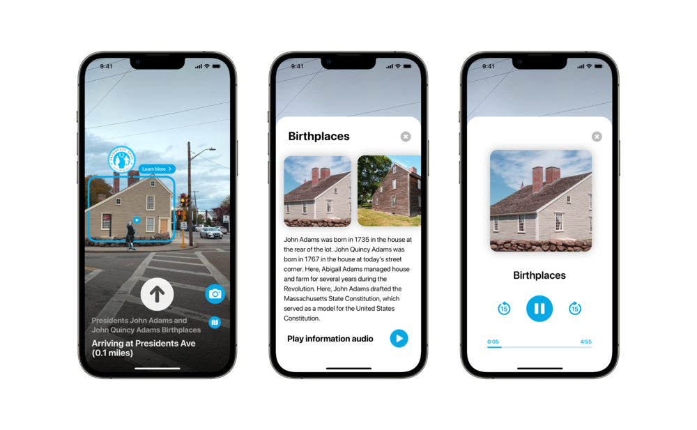
Preview of user approaching John Adams and John Quincy Adams Birthplaces with audio & readable information.


Presenting the Design Proposal to the City of Quincy — including Mayor Thomas P. Koch, Quincy Chamber of Commerce, Commonwealth of Massachusetts in December 2021


.jpg)

bottom of page